Dost dobre ... 
The Battle of the Bulge in the light of new knowledge thanks to modern technology
Categories: Second World War , Nálezy nejenom s detektorem v západní Evropě
Archaeologists have explored part of the Second World War battlefield in the Ardennes with the help of a drone equipped with a high-resolution lidar device. Thanks to laser images, the site, now covered by dense vegetation, has revealed almost 1,000 previously unknown features and experts have been able to study the site comprehensively for the first time.
The Battle of the Bulge was the last major German offensive on the Western Front and one of the largest and bloodiest battles of World War II. However, the dense forest cover has covered most of the traces of the battle in the landscape. Ordinary aerial photographs cannot see through the treetops, and the battlefield is too large to explore as a complex from the ground. Experts have therefore used airborne laser imaging - LiDAR.
"Although this is an important battlefield that has been intensively studied by military historians and is also the subject of considerable attention in museums and popular media, very little has been published about its remains," said lead author Dr. Birger Stichelbaut of Ghent University, who together with a team of researchers from the University of Toronto and Argus Vision conducted the LiDAR survey of the battlefield. "This allowed us to observe the traces of the battle on a scale that was previously unknown," explained Dr. Stichelbaut.
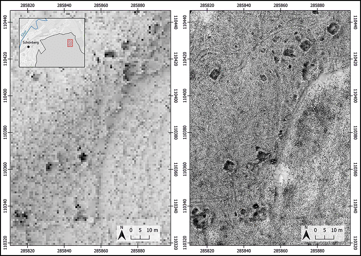
LiDAR uses laser imaging to create maps of landscapes by "seeing through" forest cover. In this case, the team used SLAM-LiDAR (synchronised localisation and mapping) technology to create high-resolution maps of the study area and then extrapolated them to the broader battlefield to better understand the features visible in the national low-resolution LiDAR dataset. This is the first SLAM application in archaeology.
Seven feature types were defined ( Figure 4 ): 1) artillery emplacement: earthen embankment and gun emplacement with shelters for artillerymen; 2) bomb crater; 3) earthwork with entrance: Excavated shelters with an earthen embankment and a clearly defined entrance ( Figure 5 ), which would be covered and reinforced with logs; 4) earthwork: A broad category of excavated rectangular shelters or storage areas with embankments, which may also include field fortifications for light artillery or mortars; 5) foxhole: A small and hastily dug shelter for one or two men; 6) ditch: straight and short sections of ditch; and 7) undefined: features that are either ill-defined or irregular in shape.
The method uncovered a wide variety of features such as earthworks, bomb craters, artillery emplacements, earthen mounds, andshelters, warehouses, shelters, ditches and, thanks to the high resolution, even individual foxholes. It demonstrates how SLAM can help solve large-scale landscape mapping more efficiently and better than ever before.
Scientists were then able to link the identified features to specific events when looking back on the ground. For example, through the discovery of German objects at American artillery positions, the team found that German forces had used abandoned American fortifications in the first phase of the offensive. Importantly, for the first time it offers an understanding of the scale and significance of the battle, revealing the three phases of the battle in the landscape itself.
"Our case study clearly demonstrates that there is potential to increase public awareness and access to some of the sites in the Ardennes," the authors state. "Recognising and designating these war footprints as heritage sites could help guarantee their long-term protection from destructive practices, including mechanised deforestation," they conclude.
Roman Němec
Sources: phys.org, cambridge.org

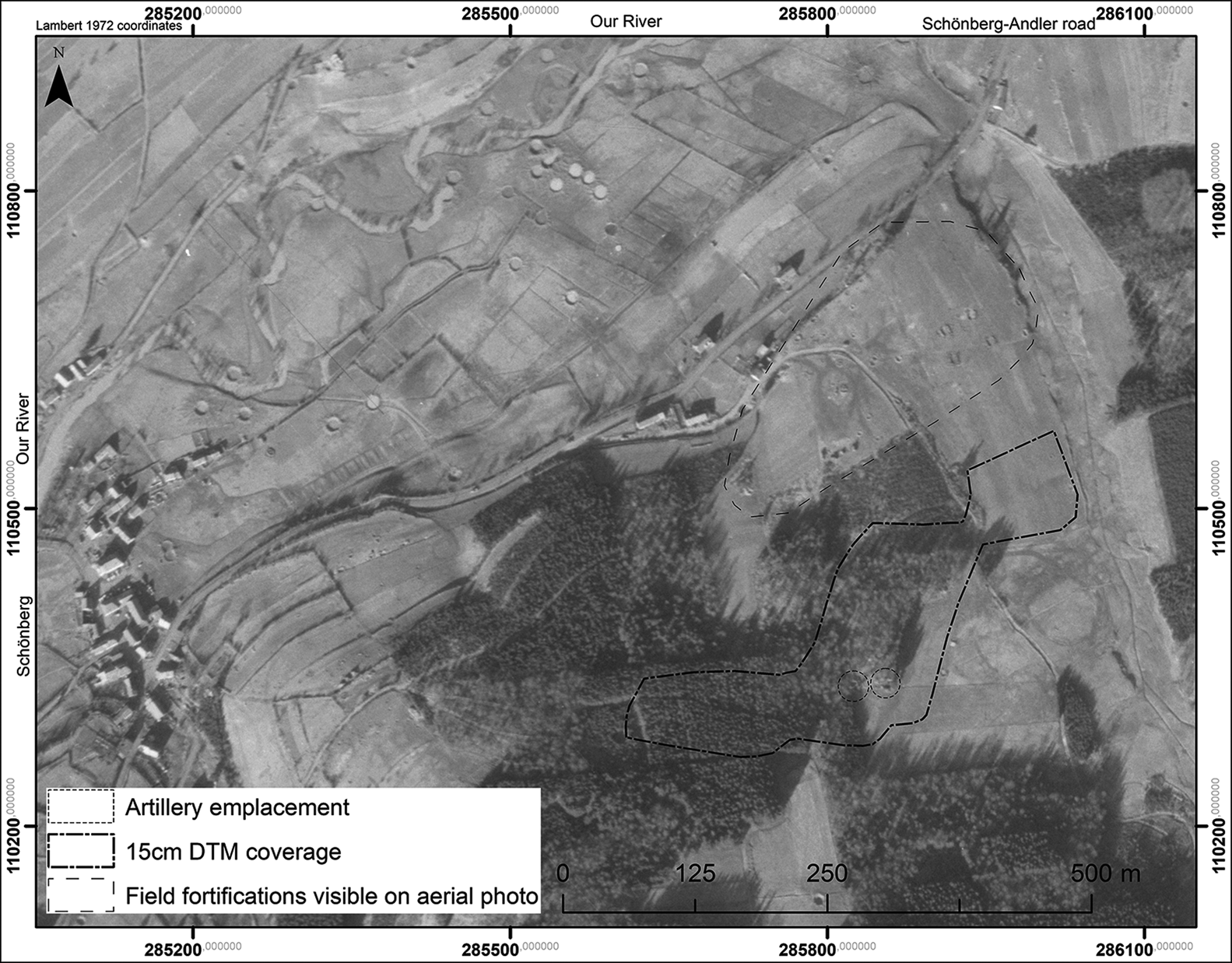
aerial image from April 1945

1m lidar resolution on the left and 15 cm resolution on the right

interpretation map

Zemljanka with entrance - external dimensions 7.4 × 9.2 m

study area

types of tracks in the field with a resolution of 15 cm-1
The article is included in categories:
- Archive of articles > Wars > Second World War
- Archive of articles > Archaeology > Finds and rescue research abroad > Nálezy nejenom s detektorem v západní Evropě
Post
Já strašně rád koukám na google foto mapy míst kde se bojovalo a nebo jen bombardovalo. Pláže Normandie či Peenemunde
Moc zajímavý. Vždycky si vzpomenu když jsem sehnal ještě na VHS v původním znění s titulky sérii "Bratrstvo neohrožených" Tam je Ardenám věnovaný celej jeden díl a filmový zpracování je fakt dobrý.🤔


